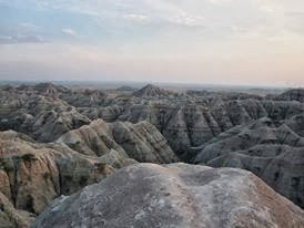
Once
upon a time, some few million years ago, there was a lake in the region
of Turkey now known as Cappadocia. As Africa collided with Europe, the
resulting volcanoes spewed ash, lava and obsidian, and the lake filled
with fine settling ash, culminating a couple of million years ago with a
thin capping layer of basalt over the once watery lake. The ash
consolidated into a 10,000 square km
expanse of tuff with unusual properties. The tuff is soft when first dug
into, but hardens to a concrete like consistency when exposed to air,
and once humans appeared on the scene they started burrowing.
We have already covered the famous surface fairy towers (http://tinyurl.com/kl6c9kw), but less well known is an ancient set of underground cities excavated deep into the rock at an unknown time around the dawn of civilisation. Extended by every community since, from the bronze age Hittites to early Christians, some of them have up to 18 explored levels, and large tracts of their extent remain unknown and unexcavated. The oldest galleries are rough hewn, and get more sophisticated the deeper one goes. Turkish archaeologists suspect their beginnings date from the Neolithic era, when early towns such as Catal Huyuk were centres of the obsidian trade around 8000 BCE. The earliest mention of them in literature was by Xenophon around 500 BCE.
The cities are well defended, with narrow low corridors and stairs between levels, that could be sealed off using tuff doors while boiling oil was poured down ventilation shafts onto prospective invaders below. The towns had all the necessary facilities, from schools and churches to breweries, wineries, bakeries and stables with fodder bins dug into the floor. Chimneys and ventilation shafts opened some way away in order to keep the location hidden. Communication shafts through which one could shout linked the levels.
Derinkuyu, found in 1965, is the largest of the 40 discovered so far, and housed an estimated 30,000 people. It is linked by a 10 km tunnel large enough for three to walk abreast to another underground city nearby. Many smaller villages have also been found, and who knows how many more remain to be discovered. The reason for dwelling underground are unknown, but could include danger from invaders and the harsh weather of the region.
Image credit: Easteighth on flikr.
http://
http://
http://
http://