Thursday, December 26, 2013

A Mammoth Mountain Christmas


There aren’t many places in California where one can find snow on Christmas. California Christmases are, for obvious reasons, typically spent trying to avoid bragging to relatives about the weather.

However, there’s one place in California legendary for its snowfall: Mammoth Mountain.

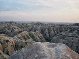
Mammoth is one of the most popular ski areas in the country. People flock to its slopes during the winter; many without pondering the unique geology that creates the snowcapped peak lost in the clouds in this photo.

Mammoth sits in a very unusual place within the Sierra Nevada mountain range. There’s a gaping hole in the middle of the Sierras known as the “Long Valley Caldera”. You can see it reflected in the flatland in the foreground of this image.

The entire flatland in the foreground of this photo is a giant volcano. It erupted over 700,000 years ago, spitting out almost as much lava as the Yellowstone eruptions. When the eruption was finished, the ground collapsed downwards into the now-empty magma chamber, forming the caldera and leaving a giant gaping hole in the center of the mountain range.

The Sierra Nevada range runs parallel to the Pacific Ocean coastline. When moisture from the Pacific tries to enter the continent, it runs into this huge mountain range and typically is dumped as snow. That is, except for one place where moisture is able to penetrate deep into the mountains…because there’s a giant, gaping hole in the center of the range.

Moisture from the Pacific is able to penetrate into the mountains near Long Valley because the highest part of the range at that point was totally blown away. But, there is one mountain sitting in the way, sitting in the path of all that moisture – Mammoth Mountain.

Why is this one mountain sitting in that path, right next to the gaping hole? Well, it’s a volcano too.

Mammoth Mountain is made up of a couple million years worth of lava flows and eruptions, piled on top of one another to build the mountain. It sits just outside of Long Valley caldera, stuck at the perfect place to create massive snowpacks. It exists because of the caldera and it receives its snow because of the caldera.

It’s still active too. In the late 1980’s, there was a series of earthquakes recorded beneath Mammoth due to movement of magma within the crust, and a large number of trees in one area near Mammoth were killed due to venting volcanic gases.

That seems appropriate for a California Christmas. A snowcapped ski course on the slopes of a volcano, sitting along the edge of a giant volcano that blew a massive hole in a mountain range.


Image credit:
http://www.flickr.com/photos/21051229@N06/5605360066 (Creative Commons license)

Nyiragongo


Africa's most active stratovolcano culminates at 3,470 metres over lake Kivu and the city of Goma on the Albertine branch of the great East African rift, where a new ocean may be in its early birth throes. Located in the Virunga volcanic field and national park (seehttp://tinyurl.com/ntwhof8) in the Democratic Republic of Congo, it is one of 8 active smokers in the field. The mountain sits at the intersection of several major faults, which allow the magma to rise from the mantle below. The extensional tectonics of the rift part the plate allowing the magma through.

The summit has a 2 kilometre wide caldera, that has had periods (including the present) of containing a long lived seething lava lake. Since the mountain's product is very fluid alkaline basalt, the convection patterns and overturns in the lake make for an ever shifting pattern of cooling black rocky crust and molten red lava. The lake existed continuously between 1894 and 1977, when it emptied in less than an hour as the crater walls fractured, engulfing several villages downstream. The lava is so fluid due to its low silica content that it can race down the steep conical sides of the mountain at up to 100kph. The flanks are littered with cinder cones. It was famously explored and studied by Belgian/French vulcanologist Haroun Tazieff in the early 70's (seehttp://tinyurl.com/m3b9oob)

It presents a serious hazard to Goma, and the 2002 eruption lava flows carved through parts of the city, including the airport runway, whose population was swollen with refugees from the endemic war that has raged in the Kivus since the 1990's. This led to serious disruption, as aid could not arrive by air until the runway was cleared. Lava flows also reached lake Kivu, prompting fears that it might cause its higly stratified waters to overturn, potentially releasing the CO2 in the saturated deeper layer and axphyxiating people and livestock, as happened at Lake Nyos (Cameroon) in 1982 (see http://tinyurl.com/qxnsx34)

It has erupted at least 34 times since 1882, sometimes continuously for years. The dense population in the area and the exceptional lava flow risk led to it being nominated a Decade volcano, and extensively studied and mapped from a hazards perspective. Ongoing conflict has made the required amount of study difficult.


Image credit: Matin Rietze
http://www.volcanolive.com/nyiragongo.html
http://www.atlasobscura.com/places/lava-lake-nyiragongo-volcano
http://www.photovolcanica.com/VolcanoInfo/Nyiragongo/Nyiragongo.html
http://www.volcanodiscovery.com/nyiragongo.html
http://ngm.nationalgeographic.com/2011/04/nyiragongo-volcano/finkel-text

Since the dam broke…


On the morning of December 22, 2008, a rumbling began along the Emory River in East Tennessee. Moments later, walls of water and ash washed around the streets, bridges, and houses of the surrounding community. A disaster few had considered possible was underway.

This image shows the end result of the Kingston coal ash spill. The smokestacks in the distance are coal-fired power plant. When coal is burnt for electricity, there is always something left over, material known as fly ash. These leftover products of coal burning contain a variety of contaminants including heavy metals and chemicals that can irritate respiratory systems.

At this plant, ash was being dumped into a retaining pond and used to build a dam. 5 years ago today, that dam gave way, and 5.4 million cubic yards of material dumped into the Emory river.

Today, the cleanup of the area is well underway, but the disaster has created a number of longstanding environmental and legal problems.

The Tennessee Valley Authority which operates the plant has spent over a billion dollars on cleanup. They paid to remove the houses of the people who lived in the affected areas, spent tens of millions of dollars building new parks and bridges for the cities that lost land, and dredged a majority of the ash out of the river.

About 10% of the ash volume is going to remain in the Emory River. Rivers are really good at dispersing sediment, so once the dam collapsed recovering every bit was never going to be possible. Some of that sediment has washed downstream while some has been trapped in isolated areas of the river. A variety of monitoring efforts are underway from the TVA and local universities to track these contaminants as they migrate towards the Gulf of Mexico.

The plant itself continues operating and construction of new holding facilities is underway.

This disaster created a variety of national and legal issues that have still not been resolved. Prior to this spill, the Environmental Protection Agency generally ignored coal fly ash and power plants dealt with it on their own. This disaster showed that setup was simply inadequate and the director of the EPA promised to issue rules by the end of 2009 for ash storage, but the EPA has yet to issue those rules. Ash like this is stored in hundreds of facilities nationwide, and at those facilities, groundwater contamination and smaller spills are commonplace.

There are also lawsuits directly relating to the Kingston ash. That ash was taken by train for disposal at a landfill in Alabama, and the local community (with a mostly African American population) has filed a civil rights lawsuit asking why the material was too dangerous to store in Tennessee but safe enough to store in their communities.

The Kingston fossil plant ash spill left a substantial mark on the surrounding ecosystems, and the ramifications continue to be felt to this day.


Image credit: Knoxville News Sentinel
http://media.knoxnews.com/media/img/photos/2009/12/19/122009flood1_t607.jpg
http://www.knoxnews.com/news/2013/dec/22/five-years-later-reviews-mixed-on-kingston-coal/
http://www.knoxnews.com/news/2013/dec/22/ulla-reeves-five-years-after-coal-ash-spill-epa/

Tohoku earthquake set off mega-landslide


This photo is one of the seemingly infinite number of shots showing damage after the great Tohoku earthquake and tsunami off the coast of Japan in March, 2011.

It was recognized shortly afterwards that the wave was very unusual. It was a “double” tsunami; two large, distinct waves were recorded by satellites and buoys throughout the Pacific, separated in time by several minutes. The presence of two waves greatly increased both the height of the waters onshore and the damage.

Consequently, scientists have spent the last few years trying to understand why there were 2 waves, in order to better prepare for future earthquakes. New research from the British Geological Survey presented at last week’s meeting of the American Geophysical Union seems to have the answer.

The earthquake set off a landslide below the waters. Not just any landslide…an enormous one…almost beyond imagination in its scale.

Using sonar images, the scientists identified a piece of the ocean floor 40 kilometers wide, 20 kilometers long and 2 kilometers thick which slid downhill during the earthquake. That estimate means that 500 cubic kilometers of rock moved in this avalanche.

It’s actually hard to find anything to compare this volume to. The largest recorded slide on land was at the eruption of Mt. St. Helens, and that was about 3 cubic kilometers. An earthquake off of Newfoundland set off a slide with a volume of 200 cubic kilometers in 1929; that slide set of a tsunami that killed several dozen people.

500 cubic kilometers is roughly the amount of material erupted from the Long Valley caldera eruption 760,000 years ago. This slide was comparable in volume to a supervolcano that knocked a hole in the Sierra Nevada mountain range.

The scientists also used seismic data recorded during the earthquake to confirm the presence of this slide. Avalanches give a peculiar seismic signature and, within the data available on this earthquake, they located that fingerprint.

It’s impossible to say how much worse the devastation in Japan was because of this slide; there is no way to separate its damage from the other wave. However, over the last century, there are multiple examples of tsunami waves generated from submarine landslides, with the one in Japan likely being largest.

These mega landslides aren’t common, but they occur often enough that they are a major threat to civilization. They can occur in places thought safe from tsunami, making them a particular threat. These submarine landslides are in need of better scientific characterization soon, before another one contributes to or causes a mega-disaster in a populated area.


Image credit:
http://commons.wikimedia.org/wiki/File:Flickr_-_Official_U.S._Navy_Imagery_-_Aerial_of_Wakuya,_Japan._%281%29.jpg

Press reports:
http://www.theguardian.com/world/2011/dec/07/japan-double-tsunami-nasa-satellite
http://blogs.agu.org/landslideblog/2013/12/17/tohoku-earthquake-landslide/
AGU Abstract: Tappin et al., 2013.

POTENTIAL DIAMOND DEPOSITS IN ANTARCTICA?


A team of Australian geologists has reported in a recent paper that kimberlite has been found in samples from Mt Meredith, within the northern Prince Charles Mountains in East Antarctica. Kimberlite is an igneous rock named after the town of Kimberley in South Africa, where in 1871 the discovery of a 83.5-carat (16.70 g) diamond resulted in a diamond rush.

Kimberlite deposits are vertical pipes intruded into the crust from deep in the mantle, sometimes carrying diamond bearing xenoliths (foreign rocks). 98% of pipes do not contain diamonds. Diamonds form from pure carbon subjected to extreme heat and pressure, about 150km deep within the Earth's crust.

Diamonds were not found in the three samples taken from Mt Meredith, though the mineral’s signature is ‘texturally, mineralogically and geochemically typical of Group I kimberlites from more classical localities’ (http://bit.ly/1chyoi7). The study focused on the region’s geology and not on potential mining sites.

This new study suggests kimberlite was uplifted about 120 million years ago, before Gondwana segmented into present-day Africa, the Arabian peninsula, South America, the Indian sub-continent, Australia, Antarctica and New Zealand. Kimberlite deposits would have originally been within the centre of Gondwana, until the continents began to drift.

Any excitement about mining rights for the potential diamonds must be curtailed, as the 1961 treaty protecting Antarctica was updated with an environmental protocol in 1991. Article 7 of this protocol prohibits any activity relating to mineral resources. This pact comes up for review in 2048 and has been ratified by 35 nations.


Paper: http://bit.ly/1chyoi7
Protocol on Environmental Protection to the Antarctic Treaty (1991): http://bit.ly/1cWEzXk
http://phys.org/news/2013-12-potential-diamond-haul-antarctica.html
http://www.bbc.co.uk/news/science-environment-25417441

Post on diamond prospecting in the Arctic:http://on.fb.me/JKQNHP

Photo: Dougie Gray, http://bit.ly/1etqynb

Sunday, December 1, 2013

Lung cancer rates soar in Beijing


Over the past couple weeks, we’ve repeatedly noted the severe smog outbreak that struck much of China as a consequence of stagnant airmasses and coal-fired power generating stations heating up for the winter (http://tinyurl.com/p9q6woa,http://tinyurl.com/p4929h2).

Of course, this year isn’t the first time China has dealt with a major smog outbreak. They’ve been dealing with major air quality issues for well over a decade; a consequence of their modernization and fossil fuel usage. This photo was taken in 2004; the grey air has only gotten worse since then.

Recently, the World Health Organization (WHO) issued an important report on the subject, suggesting that hundreds of thousands of people die every year as a direct consequence of air pollution. Specifically in 2010, they estimated that there were 223,000 deaths due to lung cancer as a consequence of air pollution worldwide.

Normally, air pollution isn’t one of those problems we worry about every day; even in polluted areas we just tolerate it or ignore it, but those WHO numbers are staggering.

New data from China fits very well with those WHO estimates. In the past 10 years, incidents of lung cancer in Beijing have increased by 60%, from 39.56 to 63.09 per 100,000 people. The Chinese government suggests, correctly, that increasing smoking rates impact this number, but it seems extremely likely that air pollution is a major factor in this increase as well. Many of those additional cancer cases are being driven by their deteriorating air quality.

Although China’s air is an extreme case, these numbers are a stark reminder of how air pollution impacts lives throughout the world.


Image credit:Jesse Varner (Creative Commons license)
http://www.flickr.com/photos/molas/49804602/

Press reports:
http://www.bbc.co.uk/news/magazine-24880737
http://www.cnn.com/2013/10/17/health/geneva-air-pollution-carcinogenic-who/

Glacially Erratic


A Glacial Erratic is a bit of stone, generally LARGE, that shouldn’t be there. They are rocks picked up by glaciers and transported, sometimes for hundreds of kilometers, away from their place of provenance to some other geologic neighborhood. Once there, they tend to stick out like sore petrologic thumbs – in many cases, they’re too big to lug away (remember, a one cubic meter of rock weighs about three tons). The largest erratic in the United States (found at Lake Stevens, Washington) is 10.36m tall and 23.77m in length.

In some localities, the solution of “What to Do with Them” has been to incorporate them into a local public square or garden designed around them, such as the erratic stone in this photo from Geneva. In fact, Ryan Thompson, an artist combining the geologic within his creations, has documented many erratics into an exhibit of stereo-paired photos that seem, well, to “wriggle” uncomfortably within their present setting (see them dance at: http://tinyurl.com/o9qzovx). In a way, this is exactly what erratics look like to passing geologists – rocks that are not at all comfortable in the geologic setting where a glacier has dumped them.

Here in Greece, our glacial erratics are blamed as being off-target stones thrown by the titans from the top of Mount Ossa at their enemies, the Olympian gods. Since the type of rock in the erratic can be traced back to its point of origin, and since so many glacial erratics in Greece do seem to trace back to the Ossa-Olympos formations, then the myth must be true, right?

Either that or those erratics are doing some amazing dancing on their own when under the influence of glaciers…


Photo courtesy of Ryan Thompson (Glacial Erratic Monuments: Geneva, 2010)

http://departmentofnaturalhistory.com/projects/glacial-erratic-monuments-geneva/
http://departmentofnaturalhistory.com/about/
http://nwgeology.wordpress.com/the-fieldtrips/glacial-erratic-field-trips/

A lonely road in Death Valley


It’s getting late in the night on Friday where I am…and for some reason that seems like a good time to show emptiness.

This photo shows one of the lonely roads through Death Valley National Park. There are mountains in the distance and a few other cars on the road, brought there by the fact that this is a national park now…but this is truly a great image of a wasteland.

Very little life. A few dead bushes mark the side of the road; the seeds for those bushes may well have come in on some of the passing cars and sprouted during one of the very rare rainstorms. There aren’t even very many large rocks; despite the nearby mountains, the presence of salt in the area breaks down the large rocks rapidly into dust and the limited rain means there are very few floods that can bring large rocks far out into the valley.

A barren, empty landscape for the night.


Image credit: Tim Furche (noncommercial use)
http://www.fotopedia.com/items/timfu-971d653170a554b7deb1b916ce26670f

Deserted by Nature: Alvord Desert, Oregon


At the bottom of every lake and sea lies a cracked and dried surface, waiting for exposure. Such holds true with the Alvord Desert and its lake that once existed but has since dried up and created a dried and abandoned exterior. Tens of thousands of years ago, a lake with a depth of nearly 61 metres (≈200 ft) rested above this now cracked and crumbled surface, before drying up and exposing the Earth’s outer shell.

Now, the Alvord Desert is the largest playa in Oregon, measuring 10km - 17km (≈6 mi-10 mi) and receiving only 12.7cm-17.8cm (≈5in-7in) of annual rainfall. The surrounding Cascade and Coast mountain ranges are responsible for this number since they geographically place the Alvord Desert in a rain shadow and prevent extensive amounts of precipitation.

Despite the overarching dryness of the Alvord Desert, geothermal springs can be found near the neighboring Steens Mountain and feed a few lingering streams that vanish into ground cracks. Steens Mountain is part of an ancient lava flow that has carved its way into the landscape and exists well beneath the visible Alvord Desert surface.

When one finds themselves standing atop a nearby mountain ridge, or at the center of the flattest part of the desert, it is hard to ignore the desert winds. It is hard to ignore the massive nothingness that exists in a place where water and life were once abundant and visibly everywhere. Dried up and nearly silent as space, the Alvord Desert is now alluring in a different way; a more subtle way that tells the story of a historic past and an abandoned beginning.


Photo Credit: Tyson Fisher
http://www.tysonfisher.com/

References:
1. http://www.blm.gov/or/districts/burns/recreation/alvord-mann.php
2. http://onda.org/where-we-work/steens/alvord-desert
3. http://yourshot.nationalgeographic.com/photos/1433914/

THE GEOLOGY OF GRAVEYARDS


If you think this is going to be a tame article on the geology of rocks that make up tombstones, scroll back through The Earth Story to some safe post on super volcanoes or catastrophic earthquakes or being wiped out by asteroids before it is tooooooo late…http://tinyurl.com/p9zsvot 

In this post, I am going to deal with the nitty-gritty spooky feature of graveyards: they are places where your body is meant to rot! The geologic environment of a graveyard affects just how this happens and, in poorly selected gravesites, doesn’t happen at all.

Squeamish yet? http://tinyurl.com/o6qoxos

First, we have to assume you’re going to die. I am, you are, we all are. No zombies allowed here: this is REAL science. What will happen to your body when you die? Since everyone on Earth is now expert on how bodies decompose due to the prevalence of CSI on global television, let me merely remind you that the rate a body rots within the ground is a function of factors such as temperature, humidity, aerobic conditions, water availability, acidity, chemical composition (of both you and the grave), and bacteria population. For a pretty fair description of the processes in action, try this:http://tinyurl.com/c3vonaw

There is even a mathematical-sounding formula called Casper’s Law (I don’t know if this is named after the friendly ghost) that states “a body left in the open air decomposes twice as fast as if it were immersed in water and eight times faster than if it were buried underground.” There are optimal conditions and combinations of conditions present for each of these factors promoting decomposition: there is an optimal temperature range for decomposition, an optimal humidity, optimal worm population. And if there isn't?

You've seen the documentaries – the desiccated bodies left from the Incan sacrifices, Otzi the frozen Neolithic Man of the Alps, catacombs in Italy, Celts left in bogs way too long… The effect of a cemetery gone wrong most often results in the production of a mummy. Too dry? Mummy. Too cold? Mummy. Bodies kept in anaerobic conditions? Mummy. Grave under groundwater, particularly one with acidic waters and tannin? Mummy.

Imagine you’re a geologist sent to inspect a potential cemetery plot (imagine that it’s Halloween to make things even better!) (Actually, I’ve done this, though thankfully not on Halloween.) There’s a great place on that hillside, really scenic, just below the rising moon – but it’s situated on an active landslide. And yes, several graveyards in local Greek villages have slipped down the valley, distributing relatives in multiple states of disrepair all over the place. No good!

But what about this quiet valley, with the willow tree and mossy path, a surreal fog on the ground, how lovely! but… unfortunately, the water table here is too high, and the water tends to stagnate. You won’t rot here, you’ll mummify, uck!

Oh here’s a great place! Water percolating through loose sands, just perfect conditions except… where does that water go to? See down the hillside? That’s the village spring. Unless you want to drink fluids liberated during decomposition, it’s to be avoided.

Let’s look at the soil. Yes, a cemetery should have soil, good soil, not just coarse rocks. If you want a good population of bacteria to do the main job in decomposition for you, you need dirt. It’s a shame that vineyard took up all the best dirt.

Pick up that rock, go ahead. Take a look. What’s that beneath it – a root? Ahhh. Perfect location! Worms already present, dirt healthy, drainage good, not too hot, not too cold, why has that root crawled off the rock, why is it crawling onto my boot, why is it…http://tinyurl.com/5fsnjk

Make sure your potential cemetery is not haunted before it becomes one.


Photo: Icelandic Cemetery courtesy of Johan Stellarhttp://johanstellerphotography.wordpress.com/tag/graveyards/
The Hearse Song performed PERFECTLY by Harley Poe.

A worthy video to watch during the witching hours: National Geographic Ancient Graves Voices of the Deadhttp://www.youtube.com/watch?v=MNpIcJwBYnQ
And several other scientific references on graveyard geology:
http://www.scientificamerican.com/podcast/episode.cfm?id=cemetery-science-the-geology-of-mau-08-10-30
http://www.freeradicalsmag.com/2009/10/07/the-geology-of-fear/
http://www.ucl.ac.uk/es/impact/geology/walks/Earth_Sciences_Geotrail_Graveyard_Geology.pdf
How Bodies Rot in Graves: http://english.pravda.ru/science/mysteries/23-03-2006/77751-corpse-0/
And… Mummies! http://books.google.gr/books/about/The_Scientific_Study_of_Mummies.html?id=P_xj3QTHHvoC&redir_esc=y

Sunday, October 20, 2013

Turkey's underground cities


Once upon a time, some few million years ago, there was a lake in the region of Turkey now known as Cappadocia. As Africa collided with Europe, the resulting volcanoes spewed ash, lava and obsidian, and the lake filled with fine settling ash, culminating a couple of million years ago with a thin capping layer of basalt over the once watery lake. The ash consolidated into a 10,000 square km expanse of tuff with unusual properties. The tuff is soft when first dug into, but hardens to a concrete like consistency when exposed to air, and once humans appeared on the scene they started burrowing.

We have already covered the famous surface fairy towers (http://tinyurl.com/kl6c9kw), but less well known is an ancient set of underground cities excavated deep into the rock at an unknown time around the dawn of civilisation. Extended by every community since, from the bronze age Hittites to early Christians, some of them have up to 18 explored levels, and large tracts of their extent remain unknown and unexcavated. The oldest galleries are rough hewn, and get more sophisticated the deeper one goes. Turkish archaeologists suspect their beginnings date from the Neolithic era, when early towns such as Catal Huyuk were centres of the obsidian trade around 8000 BCE. The earliest mention of them in literature was by Xenophon around 500 BCE.

The cities are well defended, with narrow low corridors and stairs between levels, that could be sealed off using tuff doors while boiling oil was poured down ventilation shafts onto prospective invaders below. The towns had all the necessary facilities, from schools and churches to breweries, wineries, bakeries and stables with fodder bins dug into the floor. Chimneys and ventilation shafts opened some way away in order to keep the location hidden. Communication shafts through which one could shout linked the levels.

Derinkuyu, found in 1965, is the largest of the 40 discovered so far, and housed an estimated 30,000 people. It is linked by a 10 km tunnel large enough for three to walk abreast to another underground city nearby. Many smaller villages have also been found, and who knows how many more remain to be discovered. The reason for dwelling underground are unknown, but could include danger from invaders and the harsh weather of the region.


Image credit: Easteighth on flikr.

http://www.cappadociantour.com/derinkuyu-ciudad-bajo-tierra/
http://www.turkeytravelplanner.com/go/CentralAnatolia/Cappadocia/yeralti/
http://www.cappadociaturkey.net/derinkuyu_underground_city.htm
http://www.cappadociaturkey.net/undergroundcities.htm

BADLANDS NATIONAL PARK, SOUTH DAKOTA


Badlands National Park in South Dakota consists of approximately 243,000 acres of land. The Lakota people originally called the landforms that comprise the region “mako sika,” or “land bad.” This area has extreme temperature fluctuations and little water, so the name is certainly appropriate.

The Badlands was designated a national park in 1978. Prior to this, and as of 1939, the area was considered a national monument. This means that the area has significant items of scientific, historic, or prehistoric value. A national monument designation usually protects only one significant resource. The region does, in fact, possess rich fossil life; preserved organisms from the Oligocene epoch (some 23 to 35 million years old) are found here. With a national park designation, on the other hand, a larger area and many other significant features found within it are preserved, such as the largest protected grasslands in the United States, and the magnificent buttes and sharp peaks that make up the landscape of the region. National park areas are set aside for public use for natural beauty and scenery; I can tell you firsthand that this area certainly does have breathtaking features, since I hiked the hills of the Badlands this past August.

As a lover of fossils, I am glad this region has been protected so that we can learn more about the life that came before us. As a lover of beautiful landscapes, I am also happy to know that I can come back here in the future and take it all in again.
 
I took this photo while on a hike in Badlands National Park in August 2013. I hope you enjoy it!

For more on the geologic history of this region and other badlands topography, please see:
https://www.facebook.com/photo.php?fbid=521174477943601&set=pb.352857924775258.-2207520000.1379885443.&type=3&theater

References:
http://www.npca.org/parks/badlands-national-park.html

http://www.nps.gov/history/history/online_books/portfolio/portfolio0b.htm

http://www.nps.gov/cong/faqs.htm

http://www.nps.gov/badl/faqs.htm

Thursday, June 27, 2013

Another view of Colorado wildfires


wildfire complex in Colorado, the West Fork Complex (http://tinyurl.com/puyhnc4). It turned out that just after we shared that post…NASA decided to taunt us by saying “we have a much better image”. 

I’m not sure what it is about images from the Space Station, but somehow the combination of photography and the angle makes them seem incredibly real and vibrant. Here therefore is another look at the wildfires burning in Colorado taken from the International Space Station on June 19.

You can clearly see the enormous pyroclumulus cloud formed from the West Fork Complex fire spreading out over the southern part of this image. A smaller cloud from a fire burning to the north is also visible.

A pyrocumulus cloud is a type of cloud associated with events like fires and volcanic eruptions. The cloud itself is formed when the heat given off by the fire forces the air above the hotspot to rise up into the atmosphere, carrying particulate matter such as ash with it. The clouds from this fire have been large and continuous enough to negatively impact air quality across the Eastern U.S. for the last several weeks.

Gletschergarten


This picture looks rather ordinary, just a hole in the ground with a couple of rocks. However, if you look into the story of how this hole was formed, you find an Earth story from the Ice Age, around 20,000 years ago.

This is a pothole in the Glacier Gardens (Gletschergarten), Lucerne, Switzerland. During the Ice Age, this area was covered by the Reuss glacier. The potholes found throughout the park were created by the strong force of the water as the glaciers melted. The water initially melted on the surface, then seeped through cracks and fissures. The flowing water below the glacier was under intense pressure. As it gained speed, vortices formed and carved large potholes into the sandstone below. The largest pothole in the park is about 9.5 meters deep and 8 meters across.

Josef Wilhelm Amrein-Troller discovered the area in 1872 while digging for a wine cellar. After finding some small potholes, he consulted two geologists who recognized the evidence for Ice Age glaciation. They encouraged Josef to stop blasting the area and preserve the site. Careful excavation began, and a park was opened in 1873.

The sandstone in the park is filled fossils of palm trees and clam shells. Around 20 million years ago, the climate of the Lucerne area was subtropical, with sandy beaches and tropical trees.


References:

http://www.erikburd.org/skiing/engelberg/ggarden/

http://www.gletschergarten.ch/Garden.4.0.html?&L=2

Image of a 4-meter-deep pothole, Gletschergarten, Switzerland. Credit Roland Zh
Wikimedia Commons
http://commons.wikimedia.org/wiki/File:Luzern_Gletschergarten_4.04.02_03.jpg

EARTH’S SKY FROM ABOVE


Taking a page from Col. Chris Hadfield’s interaction with social media whilst aboard the International Space Station, European Space Agency astronaut Luca Parmitano is using Twitter to share photographs he takes from the ISS. Parmitano is aboard the ISS for six months, with five other astronauts. 

Parmitano was born in Paternò, Italy and considers Catania his hometown. He arrived at the ISS on May 29, 2013, as part of the Volare mission; volare means "to fly" in Italian.

Parmitano captures his images from 400 km high, looking out of the Station’s Cupola while orbiting at 28,800 km/h. He tweeted this image on June 22 with the comment: “The sky is simply perfect. La semplice perfezione del cielo.” Earth’s curvature can clearly be seen in this image.

All of Parmitano’s photos are available here:http://bit.ly/12oZM31. You can follow him on Twitter here https://twitter.com/astro_luca and Facebook here https://www.facebook.com/AstronautLucaParmitano.


http://www.esa.int/Our_Activities/Human_Spaceflight/A_perfect_sky
http://www.esa.int/Our_Activities/Human_Spaceflight/Astronauts/Luca_Parmitano
Image copyright: ESA

Atmospheric aerosols may act to slow climate change


Aerosols are are tiny dust or liquid particles suspended in the atmosphere and air that can be both natural and man-made. Ranging from the ash of a volcano to the particles spewed by burning fossil fuels, numerous scientific studies have discovered that these aerosols actually slow global warming, contrary to prior belief.

It is important to distinguish between aerosols and the commonly referred to greenhouse gases, like carbon dioxide and methane. Greenhouse gases act as a sort of gaseous, one-way passage blanket that envelops the earth. Meanwhile, the liquid and solid aerosols suspended in the air act as both mirrors and "seeds for cloud formation", affecting global warming both directly and indirectly.

Aerosols can reflect and shoot the sun's radiation rays away from the Earth, and can also gather water in the atmosphere to create clouds. The bigger these clouds are in quantity and size (thickness), more light rays are scattered and less heat is absorbed by the earth.

Studies in and/or by Nature Geoscience, the UK Met Office, the Intergovernmental Panel on Climate Change, and other organizations have all asserted this as a very likely to be true observation.

"No question about it, they have a cooling effect" says Stephen Schwartz, an environmental senior scientist at the Brookhaven National Laboratory.

The brief explanation is this: Hurricanes are formed by the raw energy absorbed and released by the ocean. When a higher quantity of aerosols act to reflect much of the sun's rays, there is less heat by the ocean to be absorbed. Nevertheless, it is far too common to think that the number of hurricanes fluctuates based on climate change. Aerosols are simply predicted to decrease the intensity of these already heightened-intensity hurricanes.

This is not to say, however, that aerosols are 100% beneficial to the welfare of the human race by the diminishment of the hurricane's destructive power. During the last 2 to 3 decades, significant improvements in human health have been seen by the clean up and decrease in hazardous industrial aerosols.

For this reason, it is a difficult decision for me to label the presence or absence of aerosols as "better" than one another. This is because studies and observations are quite qualitative on both sides. For example, it is difficult to determine the quantifiable amount of human life loss due to human induced aerosol pollution. At the same time, environmental scientists maintain that while this relationship is a step forward, aerosols reducing global warming is a "perplexing variable" because of the lack of quantifiable data.

Nevertheless, this new discovery truly is a breakthrough. Further studies can hopefully uncover details and quantifiable aspects of this observation in the hopes of bettering planet Earth.


Image Credit: Colorado State University

References:

http://phys.org/news/2013-06-man-made-particles-affect-hurricane-frequency.html

http://scienceline.org/2007/04/environment-cooper-aerosols/

Wednesday, June 26, 2013

LA FORTUNA, COSTA RICA—THE TOWN THAT LIVED


Arenal Volcano in Costa Rica is a 1,657 meter-tall stratovolcano that has shown decreased activity since October 2010. However, in the past, this volcano was quite active. On July 27, 1968, Arenal erupted after a 400 to 500 year dormant period. Prior to the explosion, Arenal was known as Arenal Peak, since it was thought to be a mountain. In the months leading up to the 1968 explosion, the people living in the region surrounding the volcano noticed some warning signs, including ground movement, especially the night before the explosion. People who climbed Arenal noticed that the rocks making up the volcano were hot for some time. Fumaroles, or vents from which hot steam escapes, were noted on the volcano as well. However, at the time, there was no elaborate warning system set up, nor were there volcano experts in the area. As a result, residents who lived near Arenal were not necessarily aware of the impending danger.

Arenal exploded from its western side at approximately 7:30 in the morning. When the eruption occurred, farming communities that were located near the slopes of the volcano were destroyed. The three small villages of Tabacón, Pueblo Nuevo, and San Luís were decimated when 15 square kilometers surrounding the volcano were buried with rocks, ash, and lava over 232 square kilometers of land. Unfortunately, 87 people lost their lives during this destruction that lasted several days. Rocks weighing several tons were thrown more than a kilometer away from the volcano at a rate of 600 meters per second at the height of the eruption.

The town of La Fortuna (translated to mean “The Fortune”) was spared from the devastation, but people were still evacuated from the small village. As a result, La Fortuna was deserted for many months after the 1968 eruption. Some people eventually returned to the town, but many residents did not. When I was in La Fortuna, I noticed that Arenal looms not too far off in the distance, and it is plain to see why people were hesitant to return. However, La Fortuna has now become a tourist destination specifically due to its proximity to the volcano.

Because of this fateful tragedy in 1968, residents who want to live near the volcano do not build their homes very close to the site. I visited Arenal in July 2012, and I was not able to hike past a certain point as a safety precaution. Even though the eruption ended in tragedy for the community, the volcano has brought in millions of tourists to this region of Costa Rica. As a result, tourism is vital to this area.


Photo of Arenal as seen from La Fortuna courtesy of the Central Intelligence Agency’s World Factbook. (https://www.cia.gov/library/publications/the-world-factbook/photo_gallery/cs/photo_gallery_B1_cs_5.html)

References:
http://www.fortunawelcome.com/arenal-volcano/

http://travelcostaricanow.com/index.php/The_Town_of_La_Fortuna_-_Arenal_Volcano_Area

http://www.tabacon.com/pdfs_items/089_580EB8A2-BC1C-44A4-999CA2C9D77483F0.pdf

http://www.ovsicori.una.ac.cr/index.php?option=com_content&view=article&id=26&Itemid=22

http://www.arenal.net/arenal-volcano-overview.htm

http://www.arenal.net/arenal-volcano-1968-eruption.htm

http://www.arenal.net/

http://www.nps.gov/yell/naturescience/fumaroles.htm

For more information on Arenal, please see:https://www.facebook.com/photo.php?fbid=493023807425335&set=a.487272311333818.1073741829.352857924775258&type=3&theater

<a href="http://www.bloglovin.com/blog/4836329/?claim=gqhhwupxrrn">Follow my blog with Bloglovin</a>


Metro in the Desert: Utah’s Zion Subway Tunnel


For those daring enough to venture nine miles through deep canyon and desert landscape, here is a must-see. The Zion Subway, located in Zion National Park, is nestled in the desert-ridden terrain of southwest Utah. The tunnel is named after its similar appearance to urban subway tunnels; however there is no direct correlation between the two. The Zion Subway tunnel has been carved from the Left Fork of North Creek where churning water sculpts the tunnel between two peaks called North and South Guardian Angels. In order to reach this majestic and incredibly unique landscape, hikers must first trek through 14.5 km-15.28 km (9-9.5 miles) of trails, canyons, and small river beds, but the payoff is most definitely worth the adventure.

Within the hollowed out sandstone, rivers and pools of water are met with little sunlight; conditions that allow algae to flourish and turn the water into its greenish/turquoise hue. Careful to be too lured in by the algae though, as it also coats much of the surrounding sediment, making for a slippery obstacle to dance around while hiking. Other wildlife within the tunnel includes an abundant population of dragonflies, frogs, lizards, and some species of birds. In fact, the surrounding Zion National Park is home to more than 270 species of birds, including the infamous roadrunner.

As beautiful as the Zion Subway may be, caution must be taken when hiking through, as conditions in the tunnel are known to escalate quickly. Danger from flash-floods, extreme heat, and hypothermia does put adventurists at risk but shouldn’t deter everyone from venturing into the Zion Subway tunnel. Although the hike may require extensive preparation and training, the payoff of visiting one of the desert’s best kept secrets is well worth while.


Photo Credit:
Christian Bothner, National Geographic

References:
1. http://www.nps.gov/zion/index.htm
2. http://travel.nationalgeographic.com/travel/national-parks/zion-photos/
3. http://www.canyoneeringusa.com/utah/zion/visitor-info/geology/
4. http://www.nps.gov/zion/planyourvisit/southwest-desert-trails.htm
5. http://www.zionnational-park.com/zion-national-park-subway.htm

Powered By Blogger